

There is more to Peru than Machu Picchu - the Nazca lines
- Sandhills
- Jan 4, 2020
- 4 min read
There are a couple of things that come to mind when you talk about Peru. The first and foremost is, of course, Machu Picchu. This is the Incan citadel set high in the Andes mountains, an engineering marvel testament to the abilities of a group of people who had no tools, had not seen the wheel, had no system of writing and above all no knowledge of iron and steel. Yet they built, built agricultural innovations in harsh environments, architecture that wows the mind even today and an extensive trail network that connected various parts of the world. But, it deserves it's own piece dedicated to it.
The other thing that pops up is Ayahuasca, a brew with powerful hallucinogenic properties that claims to open your mind and heal traumas. This is not a recreational drug, however, and needs a regimented before and after the ritual. That requires time and therefore we passed.
There is one more thing in Peru, Nazca Lines. Wiki describes it as a group of very large geoglyphs formed by depressions or shallow incisions made in the soil of the Nazca Desert in southern Peru. These have been the subject of intense debate amongst archaeologists for quite some time now. How were they drawn? What was the purpose of these drawings? And the most fanciful one - did aliens create these?
To understand this better, let us look at the scale of these drawings.

That guard tower and the passing trailer are miniscule as seen from the air compared to the three Nazca lines drawing on the desert floor. They are so huge that you cannot fathom or see them if you were standing next to them. They can only be seen and their magnificence understood from the air. (Correction: some online research tells me they can be seen from the surrounding foothills and other high places which makes sense since the Nazcas certainly did not know of airplanes. They are still best seen from the air.)
So the things that we are sure of about these lines/drawings -
1. They were made by the Nazcas (ancestors of the Incas) - carbon dating some of the stakes found at the end of a few lines gives us a time frame of 500 BC to 500 AD which is when the Nazcas lived in those parts.
2. There are straight lines and lines which form figures of animals and plants. They vary between 0.5 km and 1 km across.
3. They were made by removing the top layer of reddish-brown iron oxide-coated pebbles to reveal a yellow-grey subsoil.
4. There is religious significance to these lines/symbols/drawings of figures
5. They were not made by aliens -
Nat Geo gives us a good definition - The lines are known as geoglyphs – drawings on the ground made by removing rocks and earth to create a “negative” image. The rocks which cover the desert have oxidized and weathered to a deep rust color, and when the top 12-15 inches of rock is removed, a light-colored, high contrasting sand is exposed. Because there’s so little rain, wind and erosion, the exposed designs have stayed largely intact for 500 to 2000 years.
The things we are not so sure about -
1. Why were they made? While there have been many theories about this, there seems to be no completely accepted one. Early archeologists thought there was some connection to astronomical purposes especially as some lines converge at a point where the sun's rays from a solstice perspective seems to have been aligned. The current agreement seems to be that the area was prone to drought and hence they served as part of some sort of ritual to appease Gods so that water could be found. But this is still in a stage of evolution as more lines are found.
2. What were those animals and birds? Again something that has evolved over time. For e.g. initial identification of the hummingbird (one of the most famous geoglyphs) is now being said to be the hermit bird. There is also a possibility some of the birds represent an extinct lineage of the current birds.
3. How many lines are there? No fixed answer. There are over 800 straight lines, 300 geometric figures and 70 animal and plant designs. Another 140 odd have been found as recent as 2018 by a team of Japanese tourists (including one found by AI).
Let us leave it at that, a learning process. We shall continue to learn, continue to refine our theories and continue to explore! Ending with a few photographs!


Getting there
The best way to get to see the Nazca lines is by air. We took a bus from Lima (the capital city where we landed) to Ica which is about 4 hours. We used the Cruz del Sur and found it quite comfortable. The only downside, all announcements are in Spanish but then again the only thing that is of importance in all the announcements is 'wear your seatbelt'!
From the Ica bus stand you can cab it to the aerodrome. Preferably book your tickets in advance especially in season. Also the best bet is to fly in the morning, in the afternoons, I have read (not experienced) that winds can play havoc with your plans. We flew with Movil Air, again not a preference since we didn't check the other operators but they were good with explanations in English. Please remember though, these are the smaller airplanes, people who are prone to air sickness - this can get really bad really fast since the plane dips and banks to allow for better picture taking.
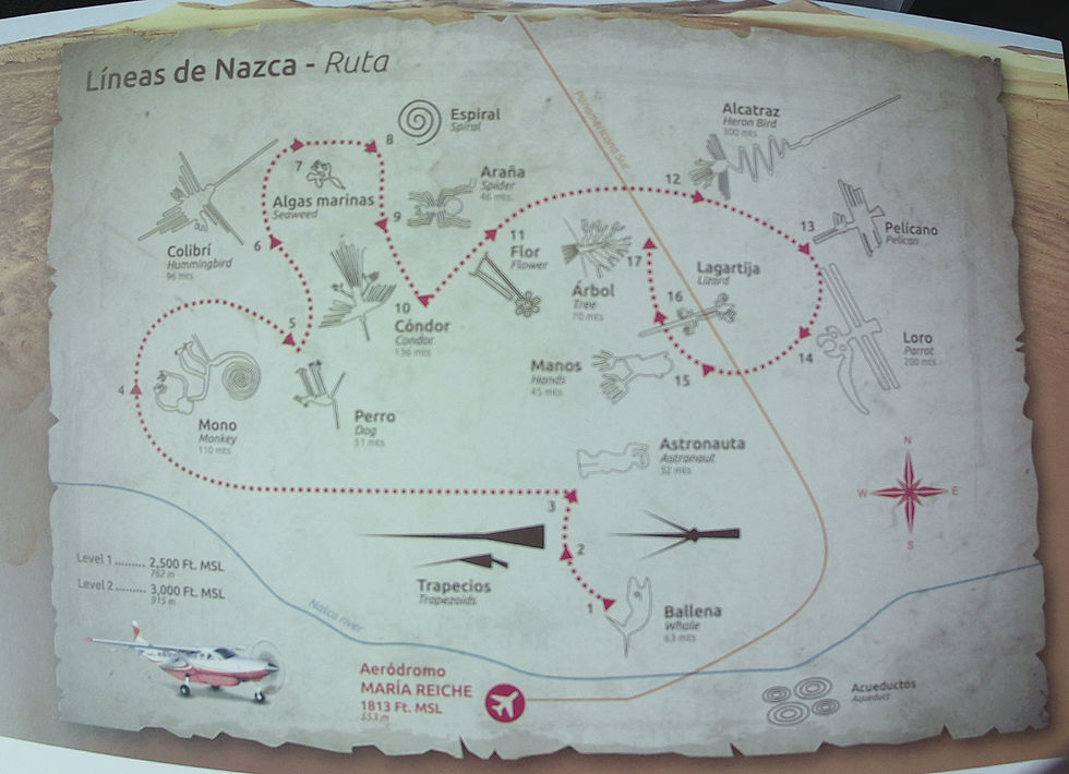
All the geoglyphs you will see!

Comments